Careers in Geospatial Analysis
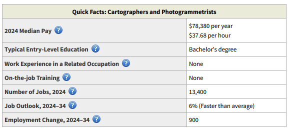
Geospatial technology is identified as a high-growth area by the U.S. Department of Labor. The Bureau of Labor Statistics describes workers doing what we now call geospatial analysis as Cartographers and Photogrammetrists. Below is the summary table showing data for the current period (2024) from the Occupational Outlook Handbook. Details state that cartographers and photogrammetrists collect, measure, and interpret geographic information in order to create and update maps and charts for regional planning, education, and other purposes. More modern job descriptions are geospatial analyst, geospatial engineer, geospatial or GIS technician, GIS specialist and the like!
Much of this growth is within UMW’s region, up and down Interstate 95. Traditionally, the federal government and its contractors have been heavy users of GIS; this is still true. Local governments, private companies, non-profits and state agencies all use GIS and look to hire broadly educated graduates with significant depth in their geospatial skills, who will help them to solve problems. Esri, the company behind the ArcGIS software used in our programs, hires many of our alumni. We increasingly see students moving to nearby states for excellent jobs.
GIS graduates will be prepared to succeed in careers such as:
- Architecture and engineering
- Cartography and geovisualization: surveying, cartography, photogrammetry, and mapping
- Environmental resource management: environmental science, scientific research, and health specialties
- Federal, regional, state and local government (resource management, transport, parks, recreation, schools, utilities, planning, etc. etc.)
- Geospatial intelligence: crime analysis, disaster management, emergency preparedness, and crisis management
- GIS management
- Technical consulting and GIS analysis
- Urban and regional planning, transportation planning, community work
Jump-starting your career
The Department of Geography helps students move towards a career in geospatial analysis in multiple ways, but ultimately it is up to the students to find and take advantage of opportunities!
Create a resume. Ask a faculty member to critique it, to make suggestions that will improve it. Make those changes!
Create a profile on Linked In and on Handshake. Connect with faculty and other students on Linked In, and join the Geography Mary Washington Group – where we post or promote internships and work opportunities.
Pay attention to emails from the department, or notices posted in the department, that may contain research or internship opportunities. Sometimes they come at short notice, at the beginning of the semester; you may need to be prepared to change your schedule to take advantage of something.
Talk to students who are doing research with a faculty member; ask how they got involved. Speak to the professor doing the research to highlight your interest – or ask a professor about possible research.
Actively look for and apply for internships, early and often! Some agencies want to hire first year students with only one GIS course; others prefer to hire rising seniors who have already completed several courses.
Think about who will provide a reference for you: faculty need to be able to honestly assess your work ethic and skills. Ask those referees before you list their names on any application!