What IS Geospatial Analysis?
The collection and examination of different types of data about place: geospatial data. The use of geospatial and remote sensing software and other state-of-the-art technologies to answer questions, carry out analyses, and solve problems.
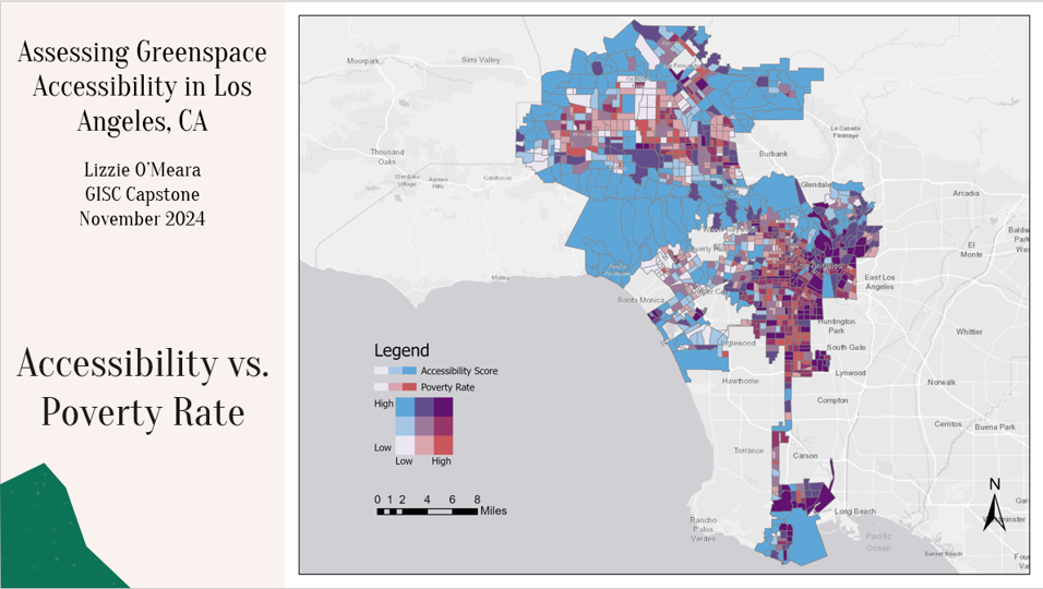
This image is taken from a Directed Study in GIS course, in which the student used freely available data to see whether accessibly greenspace (parks, public lands) is accessible to different groups of people. In this example, accessibility is compared to poverty rate (Lizzie O’Meara, HISP ’19; GISC ’24).
Geospatial technologies are pervasive in the twenty-first century, used by government agencies, private businesses, research institutions and scientists, health organizations, communities and individuals. Geospatial data is that which can be mapped: since everything happens somewhere, everything can be mapped!
Practitioners consider what happens in the world; they ask spatial questions (what happened here? why did it happen here? why does a feature occur in one place but not another?). Which route should a school bus take to be fastest? What about to be most fuel efficient? Using combinations of data it is possible to find the best location for a landfill, an airport or a new restaurant; to predict which locations are at greatest risk during a hurricane storm surge; or to map the spread of a disease, analyzing how it spreads, where it is more prevalent, and what types of communities are most at risk.
Geospatial analysis is the problem-solving arm of Geographic Information Science (GISC), which can be defined as the study and practice of methods used to collect, store, manage, visualize, analyze, and present geographic data. This is achieved through computer based information systems that integrate spatial data with conventional text and numeric data. Knowledge of foundational geographic concepts is necessary, as is cartography, confidence with computers, and strong organizational skills. Computer programming is a valuable addition but is not essential!
Geospatial data may be collected through Global Navigation Satellite Systems like the Global Positioning System (GPS), which allows geolocation of people, goods and services as well as data collection. A car’s satellite navigation system is using this technology!
Remote sensing is the capture, analysis and display of digital imagery by aerial photography or satellites. This leads to raster data, valuable in examining land cover, temperature, or other continuous variables. Geointelligence work often involves analysis of imagery.
At UMW, we use Esri software for GIS. Students are provided with a log-in that allows for download of ArcGIS Pro to a personal PC, and they are encouraged to use one of the many computer laboratories on campus to complete coursework on a desktop computer. This is how Esri describes GIS.
The Department of Geography at UMW offers a major in Geospatial Analysis and an undergraduate certificate in GIS:
- The Major in Geospatial Analysis, leads to the BA in Geography.
- A robust undergraduate certificate in Geographic Information Science can be completed by undergraduate students during the normal course of their studies, or taken by working professionals through in-person evening courses. It is well recognized by employers and will help students gain employment or enter graduate school.